
As of yesterday afternoon, the modernist building - this one - on Banks Street in the LSU Footprint...was gone, yet another piece of New Orleans modernist architectural heritage (it was designed by Colbert - same as the recently demolished Phillis Wheatley School) lost to the wrecking ball.

The property line stake appeared only recently. It's interesting because the parcel that it's stuck in the middle of - Pershing Place, a small pocket park, is still shown as owned by the City of New Orleans on the Assessor's map, the property being listed as 29348 Tulane Avenue.
Perhaps the stake marks where the highway right of way ends.
But the Assessor's record showing this parcel as still owned by the City is interesting.
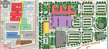
1. Is the park land supposed to be incorporated as part of the UMC project? Every map and rendering I've seen presented publicly shows the park being subsumed into some sort of plaza at the corner of S. Galvez and Tulane Avenue:

I've inquired about the fate of the statue in the park, and it sounds like VA may incorporate it into the adjacent VA site.
Still the June 2011 report on the site posted at the DOA website...does not appear to show the parcel (or the other tiny little triangular parcel immediately riverside of the park - which has no assessor record) as one of the parcels involved in the project:

One would think that the parcel would be shown below the far left lower corner if it was meant to be a colored parcel on the map.
2. If the parcel is in fact going to be transferred as some renderings show - or has been transferred - to the LSU Board of Supervisors for the UMC project...will the state have to pay or did it pay? The property is listed at $389,000. To my knowledge, the state did not compensate the city for all that land that it gained from the tearing out of the street grid in the LSU Footprint.
No comments:
Post a Comment