Saturday, January 1, 2011
How Things Stand - Visually
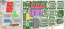
View Status of Structures in LSU/VA Footprint in a larger map
Or, to speak more accurately, here's a map that shows how things no longer stand in the footprints of the proposed VA Hospital and proposed University Medical Center.
It's pretty rudimentary at this point. There's a lot more data to add to each icon ( for now, red = demolished, blue = moved, etc.), but the icons should give you a rough idea of the fate of many of the structures in the site.
Subscribe to:
Post Comments (Atom)
No comments:
Post a Comment