
Photos in this post courtesy of Sandra Stokes.
Why did the City of New Orleans permit the VA to take out Banks Street between S. Rocheblave and S. Galvez? It really makes no sense at all - it's not like the VA's design really requires the land; it's a mid-rise hospital that could and should have been a high rise hospital on a much smaller footprint. As you can see above at left, one of the longest contiguous avenues of live oaks, planted as a World War I memorial, has been broken, the street itself torn out and plowed over.
The City's failure to attach any meaningful design-related strings to its approval to close the streets in the VA Footprint leaves the city with one of its significant secondary corridors (one lined with mature live oaks) snapped at a key point. The street no longer serves its overall function of funneling traffic off Canal and Tulane from near downtown to points far up in Mid-City, of reducing congestion on those larger thoroughfares and providing a neighborhood alternative.
The ill-conceived change has also led to unintended consequences, as I myself have found - like increased pressure on capillary roadways in the area, like the often-overlooked Manassas Place, shown here in red:

Loss of a key part of the street grid didn't have to happen.
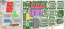
Here's the view from overhead:

1 comment:
That sucks.
Post a Comment