Showing posts with label Google maps. Show all posts
Wednesday, July 20, 2011
Google Maps starts to cross out the VA Footprint neighborhood
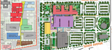
A friend sent along this image, noting the shift. While a few ghost buildings survive along Tulane Avenue and S. Galvez on the map alone, the streets are shown as gone, as are most of the buildings.
Here's a look at just a few selected VA Footprint screenshots from GoogleMaps - before the change, back when it was dense with historic houses:
Strangely, despite the change in the street map as shown in the first map, the satellite images of the area on Google Maps still shows all the houses intact.
Labels:
change,
destruction,
Google maps,
street grid,
VA hospital
Saturday, January 29, 2011
Updated Map of VA House Moving Destination Lots
I've updated the Google Map I created which depicts the destination lots of the over 70 houses moved off the VA Hospital Footprint here in New Orleans since September, 2010.
There's only one that is likely not reflected properly here, from what I can tell - the house on Conti that was moved a second time this January.
View LSU/VA Hospitals Footprint - Lower Mid-City, New Orleans in a larger map
It's very interesting to note that about 10 houses have landed in lots that are now potentially in the path of projected development associated with the "consolidated scheme" for BioDistrict New Orleans.
Labels:
BioDistrict,
Google maps,
house moving,
LSU/VA Hospital,
maps
Saturday, January 1, 2011
How Things Stand - Visually
View Status of Structures in LSU/VA Footprint in a larger map
Or, to speak more accurately, here's a map that shows how things no longer stand in the footprints of the proposed VA Hospital and proposed University Medical Center.
It's pretty rudimentary at this point. There's a lot more data to add to each icon ( for now, red = demolished, blue = moved, etc.), but the icons should give you a rough idea of the fate of many of the structures in the site.
Tuesday, November 30, 2010
Coming Into View: The House Moving Effort
Here's the latest version of the Google map showing the VA Footprint house exodus to new lots throughout New Orleans. I now have the data entered for the first fourteen "move days" - through mid-November.
Be sure to zoom out so you don't miss any:
View LSU/VA Hospitals Footprint - Lower Mid-City, New Orleans in a larger map
Wally Thurman's home, formerly at 217 S. Tonti, made it all the way to a new spot at Second and Danneel in Central City on the edge of the Garden District where it awaits rehabilitation in front of a large sycamore tree:
Monday, November 22, 2010
Mapping the VA Hospital Footprint Moves
I've continued to enter the data. Here's the first 10 "move days" worth:
View LSU/VA Hospitals Footprint - Lower Mid-City, New Orleans in a larger map
Labels:
7th Ward,
Central City,
Google maps,
Hoffman Triangle,
house moving,
LSU/VA Hospital,
maps,
Mid-City,
Treme
Saturday, November 20, 2010
Google Will Have to Revise Its Maps
I made a little map to give a rough idea of which city blocks in the VA Footprint have been entirely cleared in one way or another:
View Overall New Orleans VA Hospital Footprint in a larger map
The next project is creating an interactive map that permits you to see what happened to all the individual properties on that map - whether they were demolished or moved. As I've noted, I'm already working on the map showing the new locations elsewhere in the city for the houses that were moved off-site.
Tuesday, November 9, 2010
Note
If you click on the icon under "The Proposed Footprint" over on the sidebar, you'll notice that the GoogleMap no longer shows the footprint boundaries alone.
I've begun to add in blue markers showing the location of the moved houses (denoting their original address as well). I've only entered the first dozen or so, which means there are quite a few more to go. But it starts to give an impression of the dispersal.
Monday, September 20, 2010
A Better Map of the Footprint
Or Footprint and its component footprints, to be more precise.
Visitors to the site have always been searching for maps of the VA and LSU Footprints, and until I created the linked Google map today, there's never been an adequate representation on the blog. I've replaced the old sidebar link, so clicking on the colorful icon at the top of the sidebar will now take you to the map hyperlinked above.
Notes for anyone who uses Streetview feature on the map...
1. The shots are from a moment in time that's closer to the immediate aftermath of Katrina.
2. The City of New Orleans imposed a moratorium on even repairing properties in the Footprint for a period post-storm in anticipation of the proposed hospitals.
3. The Streetview shots do not at all reflect the many changes in the VA Footprint due to demolitions and house moving that have transformed the area in the past four months.
Subscribe to:
Posts (Atom)