Strangely, a Times-Picayune story this Saturday made no mention of any provisions regarding McDonogh No. 11 in a written agreement formalized recently between the City of New Orleans and the State of Louisiana about design changes in the LSU Footprint.
Today, however, we received word that six out of seven city council member here in New Orleans have signed onto two letters (drafted by the Fielkow office) calling for saving and incorporating McDonogh No. 11 into the 37-acre UMC hospital complex design rather than demolishing the building. One letter is headed to the chair of the UMC Board, the other is off to the head of the state's Office of Facilities Planning and Control. Council Member Jon Johnson was the only member who did not sign on.
I'm grateful to the members who signed the letters. They deserve thanks for recognizing the value of the building and for doing something right, no matter how late in the game or what may have transpired to date. There is a better way forward.
Monday, February 28, 2011
Photography Event on Wednesday - Featuring Footprint Photos

Photographer Stephen Hilger, who has been out shooting in the LSU/VA Footprint for some time now, has an artist's talk at Tulane on Wednesday, March 2 that includes a number of powerful Lower Mid-City images.

Here's a bit from Stephen himself:
I'm giving a public talk at Tulane this Wed, 3/2 at Tulane University's Stone Auditorium (210 Woldenberg Art Center). It's an artist talk on my photography including work made in the Lower Mid-City neighborhood during the past two years.
My photographs investigate notions of history, place and the social landscape. Working on projects that unfold over extended periods of time, my work constructs visual archives of the disappearing. I seek to collect and consolidate the fragmented touchstones of what is passing in the face of change and destruction.
I've had a chance to get to know Stephen through his work in the footprint, and I'd encourage you to attend.

*All images in this post courtesy of Stephen Hilger.

Friday, February 25, 2011
Salvage Issues
I have a number of issues with this piece - because despite being glad that some salvage occurred in the LSU/VA footprint, I've documented a number of concerns about the salvage process on and off the blog.
If I have time this weekend, I will elaborate.
If I have time this weekend, I will elaborate.
Thursday, February 24, 2011
Roofless

Two of the final three houses left in place on the VA Footprint stood with their roofs largely removed this evening. The purple house, in the foreground, and the gray camelback behind it were home to the last residents in the VA Footprint. They will be moved off site in coming weeks to vacant lots provided by Providence Community Housing for rehabilitation.
Along S. Rocheblave

This evening, I was out photographing the S.W. Green Mansion along the edge of the VA Hospital Footprint. High winds were blowing dust everywhere when I encountered Ms. D standing outside her residence. She told me about the many inconveniences that have piled up for the people living just outside the footprint - the people who weren't planned for. She was quite upset, and said she recently had to go to the hospital due to breathing problems she blamed on the site preparation just across the street where tons of river sand have been placed as fill on the roughly 30 acres of cleared land.
Her neighbor, also upset, asked me to wait a minute. When he returned, he laid out a long row of medications and said that all of his troubles stem from the hospital project work across the street - and the dirt road track that passes for a street itself. He insisted that I take a photo.

Another neighbor is actually a construction worker - and he, too, pointed out the many failings of the site preparation work when it came to inconveniencing and endangering neighbors.
Poor Derrick Morrison, who was flyering the area for the Committee to Reopen Charity, got an earful from the residents - who peppered him with complaints and questions about problems that were not his doing. The dust, the lack of sidewalks, the gaping open holes, the vibrations, the occasional intense lights shining in windows at night, the occasional pitch darkness, construction debris and equipment in yards, the general uncertainty, etc., that were being caused by government actions - are things Derrick has consistently raised as issues for the news media and for city officials on behalf of the residents. In fact, I'd say he's done more for the residents affected by the project than just about anyone else.

Across the way, a band of kids chanted in unison as they pretended they were in a military unit or a band and marched across the VA Footprint - with stakes of some kind in hand.

Report from the Job Fair
I stopped by the Builders of Hope job fair in Hoffman Triangle this morning shortly before noon.
By that point in the day, in the church's Fellowship Hall, over 60 people had already stopped by and filled out applications for jobs in the construction trades.
Apparently, at least 20 people were lined up at 9:40 a.m. before the fair even opened.
Catholic Charities was also onhand to take applications for a variety of additional jobs beyond the house-moving-related jobs that Builders of Hope has in play.
Wednesday, February 23, 2011
Peripheral People, Continued
Residents of the neighborhood just above the VA Footprint continue to seek redress from the City of New Orleans for property damage from construction activity:
ABC26 reports.
As does WWLTV.
Interestingly, the ABC26 report says that some "legal claims issue" exists between residents and the city. That's why the city refused to talk about the matter. Is filing a complaint with the contractor really a legal claim, though?
ABC26 reports.
As does WWLTV.
Interestingly, the ABC26 report says that some "legal claims issue" exists between residents and the city. That's why the city refused to talk about the matter. Is filing a complaint with the contractor really a legal claim, though?
Ellgee Shop: UNIFORMS

One of dozens of businesses that operated in the LSU Footprint as of 2008, the store along heavily trafficked Tulane Avenue remains in business in the site.
A Slice of Mauritania

In Lower Mid-City.
Off in the distance, across the 30-acre site, you can see the S.W. Green Mansion up on wheels at the far left. On the right, the house Robert Rogers once rented on Palmyra is now an island - complete with the random palm tree that crews left intact for some reason.
Besides Rogers' place, there are only two other houses to be moved - the gray house with brown roof way off in the distance and the purple shotgun just beyond it.
The pump house, with its orange clay tile roof, will also seemingly stay. If you zoom in, the large Pan-Am building will stay as well - it's being renovated right now, and the numerous sunshades around the outside of the building that make its appearance have largely been removed.
Still Keeping Tabs

As of last evening, this pile of fill had appeared in the 2100 block of Palmyra in the LSU Footprint.
Otherwise, besides a patch of sidewalk near McDonogh No. 11 getting repaired after utilities of some sort were seemingly cut, little has been happening in the LSU Footprint as of late.
Builders of Hope Job Fair Tomorrow

This is good news - the job fair in Hoffman Triangle/Central City (map of event address) means that significant rehabilitation work on the moved houses is likely starting in the near future.
Tuesday, February 22, 2011
Chess Pieces at Night

The four houses temporarily along S. Galvez have been moved from their original sites within the VA Footprint. And they will be moved again inside the footprint.
For now, I'm very happy to report that fencing has been placed conspicuously around the houses, and I caught crews from Tim Clark Construction working to put a protective wrap up on the back side of the buildings where they had been cut away from their attached rear portions.

Workers on ladders hammered away after dark.

What about the existing parking deck in the LSU Footprint?

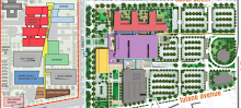
One of the handful of concessions Mayor Landrieu was able to wrangle from the state with respect to the design of the UMC hospital was a commitment to build not just the planned one, but two multi-level parking structures along Tulane Avenue. This ostensibly helps to alleviate the excess of surface-level parking that was planned for the site; apparently green space is going to fill some of that expanse.
But in the final design presented at the UMC Board meeting late last year, the illustration shows the existing parking ramp on the site, shown above at S. Derbigny and Cleveland Avenue (the front is on Canal Street), as demolished, along with the adjacent Grand Palace Hotel. Then again, the final design didn't actually incorporate the concessions made to the Mayor - the architect presenter simply noted on the original design where the second parking ramp would go.
Why not keep the existing parking ramp intact, though? The block is otherwise shown as becoming surface level parking, and unless there are some sort of hidden, crippling structural problems, it seems unwise to demolish an existing higher capacity parking structure with a minimized footprint to make way for reduced capacity lots that take up more room for the same number of cars...especially when higher capacity structures are going to be built new elsewhere on the site.
Monday, February 21, 2011
Blue House Strut

A friend captured the above shot as the blue townhouse that once stood at the corner of S. Tonti Street and Cleveland Avenue pulled away from its former site yesterday and began a slow promenade across the VA Hospital Footprint in Lower Mid-City. On the left, you'll note one of the three residences that remains in place - the gray camelback that belonged to Deborah Brown-Cassine. On the right, you'll see one of the remaining live oaks on the last remnants of Cleveland Avenue.


The blue house was the last of the four "VA Houses" that are to be retained and moved intra-site by the VA for inclusion in the complex.

Deutsches Haus eyeing possible location on Bayou St. John
From the Times-Picayune:
Here's a link to a map showing the site.
Here are the property details from the Division of Administration website.
The German heritage society is in negotiations to purchase a state-owned property at 1700 Moss Street, a vacant parcel that was previously the home of the 3rd District police station and, long before that, a Confederate veterans home. The state recently put the 4 1/2 acre site up for sale as surplus property, and Deutsches Haus was quick to act, according to treasurer Al Bourg.
Here's a link to a map showing the site.
Here are the property details from the Division of Administration website.
Saturday, February 19, 2011
Losing the Live Oaks

More live oaks were going down yesterday along the last little schniblet of Cleveland Avenue in the VA Footprint. The street, too, was being torn up.

So it goes.

And then there were two

By yesterday afternoon, two of the VA's "intra-site" houses were lined up backward along S. Galvez.
The second one moved to the area is the former 2402 Cleveland Avenue - seen on the left below, with the small rear portion of the house chopped away.


"Find a way to save McDonogh No. 11"
Yes, indeed.
I never thought I'd see the day, but the Times-Picayune published an editorial today calling on the state to save McDonogh No. 11 School. It caps off a week of concerted effort to highlight the longstanding issue:
I never thought I'd see the day, but the Times-Picayune published an editorial today calling on the state to save McDonogh No. 11 School. It caps off a week of concerted effort to highlight the longstanding issue:
"The new medical center and the research that is expected to be attached to it is important to the future economic viability of the city. There ought to be a way, though, to get moving on the hospital without subjecting McDonogh No. 11 to the wrecking ball."
Thursday, February 17, 2011
Landfill - and the overall equation
From the final Programmatic Environmental Assessment (PEA) for the two footprints:
It's unclear what the total amount of waste will be now that the house moving effort has reduced the overall amount of tonnage that ultimately went to the landfill. The S.W. Green Mansion alone weighed in at 22 tons and was ultimately diverted from the path to the dump.
And that makes me wonder. What landfill has been receiving all the debris? And would the landfill have received nearly as much...if the hospitals hadn't decided to build in the midst of a neighborhood?
For many of us who have been following the hospitals issue, there remains a fundamental question: why did they need so much land, why did they cap the hospitals at 6 or so stories in height, why did the hospitals footprint ever expand above S. Galvez as the Regional Planning Commission suggested - why did the powers that be decide to take up 67 acres of neighborhood? For any benefits that might be conjured up, the "Tulane-Gravier" site in Lower Mid-City entails some incredible pitfalls - hundreds and hundreds of individual parcels, a sizable population, lots of potential roadblocks and liabilities. The equation has never seemed to add up, which has long led me to believe there's some additional variable out there. But I've tried to avoid speculating excessively on the question or devolving into conspiracy theories.
Still, it seems to me that there are three potential items that could use far more study in pursuit of the "x" factor that may have tipped the scales: 1. Real estate deals in the footprints, including land speculation after Hurricane Katrina (Squandered Heritage, SaveCharityHospital.com, and other sites have already delved into this to some extent, but it's no simple thing), 2. Subcontracts for demolition and construction, and 3. The landfill trail - that wouldn't have existed to nearly the same extent if the footprint had been far smaller.
"Demolition and site clearing at the proposed VAMC and LSU AMC sites, mostly consisting of commercial and residential structures (15.4 tons per 1,000 square feet) and concrete floors and paved surfaces (53 tons per 1,000 square feet), would create about 137,000 tons of solid waste, with approximately two-thirds coming from the LSU AMC site. About 80 percent of the waste would be from paved surfaces and concrete floors."
It's unclear what the total amount of waste will be now that the house moving effort has reduced the overall amount of tonnage that ultimately went to the landfill. The S.W. Green Mansion alone weighed in at 22 tons and was ultimately diverted from the path to the dump.
And that makes me wonder. What landfill has been receiving all the debris? And would the landfill have received nearly as much...if the hospitals hadn't decided to build in the midst of a neighborhood?
For many of us who have been following the hospitals issue, there remains a fundamental question: why did they need so much land, why did they cap the hospitals at 6 or so stories in height, why did the hospitals footprint ever expand above S. Galvez as the Regional Planning Commission suggested - why did the powers that be decide to take up 67 acres of neighborhood? For any benefits that might be conjured up, the "Tulane-Gravier" site in Lower Mid-City entails some incredible pitfalls - hundreds and hundreds of individual parcels, a sizable population, lots of potential roadblocks and liabilities. The equation has never seemed to add up, which has long led me to believe there's some additional variable out there. But I've tried to avoid speculating excessively on the question or devolving into conspiracy theories.
Still, it seems to me that there are three potential items that could use far more study in pursuit of the "x" factor that may have tipped the scales: 1. Real estate deals in the footprints, including land speculation after Hurricane Katrina (Squandered Heritage, SaveCharityHospital.com, and other sites have already delved into this to some extent, but it's no simple thing), 2. Subcontracts for demolition and construction, and 3. The landfill trail - that wouldn't have existed to nearly the same extent if the footprint had been far smaller.
Interesting

Heading up Cleveland Avenue today in the LSU Footprint, I was surprised to see a moved house backing S. Galvez. It's the former 2336-38 Cleveland Avenue, one of the four houses that are to be moved intra-site by the VA for incorporation as transitional housing units in the complex. I have always heard that the four houses would be arrayed along S. Rocheblave as a means of giving the VA Hospital complex a "neighborhood edge" facing the neighborhood above S. Rocheblave.
So, while I knew that the houses were about to move, I didn't anticipate seeing any of them along S. Galvez - at the opposite end of the VA Footprint.

I haven't heard from anyone as to what prompted this maneuver. My guess is that the anticipated "surcharging" of the site with about 6 feet of dirt may have led to this (temporary?) siting given some particular factor. The S. Galvez end fo the footprint is also seemingly a bit higher in elevation, so perhaps it doesn't need as much surcharging. That's speculation at this point, however.
Still, the house, as you can see above, is not on its tires like the S.W. Green house - but on wooden block towers instead.
Wednesday, February 16, 2011
Dixie Owners File for Temporary Restraining Order

The owners of the high profile building, given that expropriation of the property is anticipated, filed for a TRO today with Judge Giarrusso in Civil District Court here in New Orleans. Burgos and Evans have been retained as counsel.

The Dixie Brewery, constructed in 1907, is a landmark, and I hope that it can be saved.

*All photos in this post courtesy of Ms. Sandra Stokes
#1
New Orleans isn't the #1 dying city in America. Not by any means.
But New Orleans has permitted parts of itself to be killed off following Katrina...like Lower Mid-City.
I wonder what the mayors said yesterday when they visited the site of the proposed hospitals, as they surveyed the devastation:
'At Dooky Chase's in the 6th Ward on Monday morning, iconic chef Leah Chase gave them "instructions" on their work before they walked from the first phase of Faubourg Lafitte, the remade Lafitte public-housing development, to the LSU-VA hospital footprint in Mid-City. Along the way, they made several stops to discuss the Lafitte Greenway, the Claiborne Avenue Corridor and the possible removal of the elevated expressway, a renewed Canal Street and new streetcar lines."
From the Press Conference
A number of clips from yesterday's McDonogh No. 11 press conference made their way onto last evening's newscasts. Here's a succinct one ABC26 that gets the point across in a nutshell:
ABC26- WGNO
ABC26- WGNO
Update on the VA Hospital Footprint

Last evening, the four houses that will be moved within the VA were in various stage of preparation for moving, like the two houses depicted above.
Besides those four houses and the three structures that will stay in some form - Dixie Brewery, the pumphouse, and the Pan-Am Building, there are three homes that will either be demolished or moved in the very near future: Robert Rogers' former residence, Deborah Brown-Cassine's home, and the little purple shotgun that Joan lived in.
Here are some additional items from last evening's VA Neighborhood Meeting (not exhaustive by any means):
- When the site is fully cleared, an 8-foot fence will go up around the site and dirt berms will be built around the perimeter
- The site will be "surcharged" - approximately six feet of dirt will be placed on top of the entire site to "de-water" it
- The projected final move date for the S.W. Green Mansion is March 2, 2011
- Once the Footprint is entirely clear, the state/LSU will transfer parcels gradually in batches to the VA; title to the land will never vest with the City of New Orleans even though the City is a sort of middleman between VA and LSU in the site prep. process
- The boring currently underway on the VA Footprint will include 14 borings around the site to test the soil's load-bearing capacity
- With respect to Dixie Brewery, no expropriation has occurred and neither VA nor the City have access to the building at this time to ascertain whether it is structurally sound. A team is in place and will assess the building "as soon as [it] can." The VA's intent, conditioned as it is, is to retain the red brick tower portion of the building in keeping with the April 2010 renderings.
- Cleveland Avenue streetwork underway in the 2500 and 2600 blocks just outside the VA Footprint since November is scheduled tentatively to wrap up in March
- It was unclear whether there's been full compliance with the PA's recordation requirement for the Pan-Am buildling; interior recordation has apparently not been done due to abatement issues, but some exterior recordation has been completed. Something to follow up on.
- VA officials said that VA had "partially funded" the move of the S.W. Green mansion; I was under the impression that VA had fully funded the move until last night.
- The VA's contractor, Clark/McCarthy, is devising a vibration monitoring plan for the construction phase of the project. It was unclear whether and when this would become public knowledge or if there's a way to comment - but the State Historic Preservation Office will review the plan at some point.
Residents and property owners in the neighborhood immediately above the VA Footprint were onhand. They expressed concerns about vibration (and damaging effects on their historic homes), drainage, dust, possible lead contamination, street access to homes, street traffic increases, how construction crews would access the VA site, piledriving, trash, and more.
Tuesday, February 15, 2011
Midnight Mansion

The S.W. Green Mansion sits atop steel beams atop tires atop wooden mats atop the dirt of the VA Hospital Footprint. A generator-powered floodlight lights the building where it rests in its temporary location at the edge of the VA Footprint. It will ultimately be moved just across the street to its final destination lots.
Stone Placards Removed Today from McDonogh No. 11
Shortly before our press conference this afternoon, I noticed that the two stone placards embedded over the doors of the 1879 school building had been removed, leaving underlying brick exposed.

One noted the name of the school and listed various figures and personages associated with the project.
The other commemorated the death of the two firefighters killed while fighting a blaze that destroyed the Madison School, which preceded McDonogh No. 11 on the site (link to image).
A source in the footprint informed me that OPSB, who still owns the building, came and had them removed pre-emptively. That's encouraging, because OPSB officials seemed cognizant last week of the importance of the placards and said they were going to donate the one dedicated to the firefighters killed in the line of duty to a local firefighters' organization.
Hopefully the school will remain and the stone pieces can be put back in place.
Reminder
Press conference today in the LSU Footprint - calling for the McDonogh No. 11 School to be incorporated into the UMC hospital complex design and adaptively reused.
Monday, February 14, 2011
Panning In on the Pan-Am Building in the VA Footprint

In recent weeks, crews have been taking the "sun shade" panels off the perimeter of the former Pan-Am Insurance building in the VA Footprint. The Skidmore, Owings, and Merrill building is being incorporated into the VA Hospital complex.

Under the Programmatic Agreement for the site preparation, the developing parties have a number of obligations with respect to treatment of the building:


Has the City posted summary reports of stabilization measures for the Pan-Am building to the dedicated Website? If my understanding is correct, VA already has control of the actual property - and has had control for many months as actual holder of title (we've heard from City and VA officials since the fall that the Pan-Am building was the only parcel owned by VA thus far), since the early or mid fall of 2010 at least. Indeed, the sign out in front of the building, put up by Clark/McCarthy, the construction - not demolition - contractor for the VA itself, noted today that there have been no lost time accidents on the site for 130 days:

More importantly, was the required recordation conducted prior to the present renovation work getting underway? Work on the building was already underway in the fall. Here's what I wrote, in green, in response to items in VA's November 24, 2010 "Interim Progress Report on the Programmatic Agreement dated 11/21/2008":
• VA will commence documentation of the Pan-American Life Insurance Company Building and
Dixie Brewery when provided access to these structures. (Stipulations V.B.2.(c).iii., and
V.B.4.(b).ii). It is anticipated that documentation of these structures will take three months to
complete.
VA has already had access to and control of the Pan-Am building for several months. It has also commenced a significant amount of work on the property, such as repainting the uppermost portion of the building. Why hasn't the documentation already been completed?

There will be...

...boring. Or drilling, or test pile driving. Or something to that effect. Note the S.W. Green mansion peaking over the apparatus from its temporary location.

The machine, which had an auger of some kind on when I passed by, appeared at the Canal/S. Galvez corner of the VA Footprint today.

Passengers on the Canal Street streetcar looked on as they passed.
OPSB Fighting State on McDonogh No. 11 School
Rumblings emerged several weeks ago, but on Thursday, at a preservation event, things became a bit more clear.
The Orleans Parish School Board is currently fighting the state, legally, over the amount of compensation proposed for McDonogh No. 11 School in the LSU Footprint.
According to OPSB officials, the state is apparently offering or valuing the building at $2 million, but the state is seeking replacement cost - the cost to building another school - because it was a public facility. OPSB says the replacment cost is $26-$30 million. Just a slight difference. A total of approximately $7 million was spent renovating the 1879 school building in the preceding decade - $3 million prior to the storm and $4 million after.
It does not appear that OPSB is looking to retain the school on into the future or prevent demolition; it is simply seeking what it feels is just compensation for the property in the path of the proposed hospital. As you likely recall, the students of what was Priestley Charter School were forced out of the school over the holidays and are now attending modular units out on Almonaster Avenue. A major New Orleans law firm has been retained by the OPSB, although the building had not technically been expropriated as of last Thursday evening. Despite that fact, the state's contractors were onhand as Cox cut various lines going to the school building some weeks ago.
I do not claim to be an expert in the nuances of Louisiana's law regarding eminent domain by one public entity against another. But one figure close to the story noted on Thursday that the fact that the state was expropriating a public building mean that the legal uncertainties could result in "OPSB simply expropriating it back" - which sounded pretty interesting. I am not aware of OPSB's expropriation powers - or if it has "quick take" authority like the LSU Board of Supervisors, the entity expropriating properties in the Footprint.
I also learned that the School Board intends to give the stone marker above the door at McDonogh No. 11 to the city's firefighters - it commemorates the death of two firefighters who died in the line of duty fighting the blaze that destroyed the Madison School, an earlier building on the site.
Sunday, February 13, 2011
Press Conference in LSU Footprint set for Tuesday
GROUPS TO CALL FOR SAVING McDonogh No. 11 School BY INCORPORATING IT INTO UNIVERSITY MEDICAL CENTER DESIGN
What: Press Conference
When: Tuesday, February 15, 2011
Time: 1 p.m.
Where: McDonogh No. 11 School (former Priestley Charter) at the corner of Palmyra Street and S. Prieur Street in the UMC Hospital Footprint, Lower Mid-City, New Orleans
Organizations: National Trust for Historic Preservation, Foundation for Historical Louisiana, Committee to Reopen Charity Hospital, Louisiana Landmarks Society, and allies.
A number of speakers will present the case for avoiding demolition of the beautiful, historic school building built in 1879 after a fire that killed two firefighters in the line of duty. Students of the former Priestley Charter School were forced out of the school building over the holidays in the middle of the school year. Incorporating the building into the proposed hospital complex is possible as HUD has expressed concerns over the current design due to financing uncertainties.
Additional parties will be present for media interviews following the main press conference. A full press release will be available at the press conference.
In 1942

the S.W. Green mansion at 219 S. Miro was auctioned.
A friend of the blog was kind enough to send along the clipping from the newspaper, which provides a nice description.
"You'd have to figure the complex was certain to be built if work had begun to turn a vast tract at the heart of New Orleans into a wasteland. It wouldn't make much sense to acquire property and commence demolition before the money had been lined up to fill the void left by the closure of Charity Hospital."
And yet that's precisely what has happened. Demolition and property acquisition proceeded despite a lack of funding. You're well aware of that if you're a regular reader of this blog.
James Gill at the Times-Picayune points out just how foolhardy the backers of the proposed UMC hospital have been - and notes that signficant hurdles and uncertainties remain.
After mentioning that the proposed hospital would need an unsustainable $70 million annual subsidy, he also does something that I'm sure will raise the ire of folks at LSU and the state - he re-floats the idea of going back into Charity Hospital.
Saturday, February 12, 2011
So how did the S.W. Green Mansion get saved?

Obviously, the physical act of elevating and moving the house was critical - the VA, Builders of Hope, SHPO, Orleans Shoring, the City of New Orleans, Durr, Jacobs, and others were all involved in the undertaking that played out in the VA Hospital Footprint yesterday. But what led them to take such an approach with a house that would otherwise have been demolished as planned?

Architect Kenneth Bryant was, for most intents and purposes, the prime mover, as I noted earlier. Here's a somewhat disjointed and likely inadequate history of how the building came to be saved:
In February of 2009, New Orleans Magazine published a brief snippet about the house and its noted occupant and owner in its "Julia Street" section. It's unclear that this snippet had any subsequent impact in the months that followed. I never saw the actual tidbit until this month.
In December 2009, Kenneth Bryant wrote up a press release about how he had re-discovered the house and its importance while skateboarding through the area as a student at Tulane's School of Architecture. I was not privy to the press release at the time, and it's not clear that any outlet published anything as a result of it.
Just over a year ago, in January 2009, my friend Curtis, who started out Inside the Footprint with me, made this post:
This residence at 219 S. Miro St. was once home to Smith W. Green, who, around 1908, was Supreme Chancellor of the Knights of Pythias of North America, South America, Europe, Asia, Africa, and Australia. In addition to authoring major works on Pythian history and ritual, Green was integral in the construction of the Colored Pythian Temple, which still stands at 234 Loyola Avenue.
He clearly drew on the Julia Street note to highlight the importance of the building as we began to comb through the neighborhood (which had already been done at an earlier point by PRC and Squandered Heritage, among others).
Then in, June of 2010, a Tulane student of photographer Stephen Hilger was taking photos with me in the LSU Footprint. She later forwarded a press release that a relative had received in April of 2010. It was Bryant's write up. I shared it with a number of contacts - many of whom, despite being involved in the hospitals fight for some time, did not know about the mansion's significance.
In July 2010, the Preservation Resource Center's blog featured a short piece on the house based on Bryant's work. I noted the piece here at the time. A friend of the blog suggested some Tulane historical archive pieces on the Knights of Pythias organization that Green headed.
After a tumultuous late summer for me, I ultimately worked with Bryant to post his piece in its entirety at Inside the Footprint as a guest post on September 1, 2010, shortly before the general house moving effort got underway in the VA Hospital Footprint. But the Green mansion was still, at that time, slated to be demolished.
Once the piece was published in full online, it began to be emailed around rather vigorously for several weeks, as was vaguely apparent from a review of the blog sitemeter at the time.
By October 3, 2010, an open house forum on the S.W. Green Mansion had been set, which was to be moderated by Bill Rouselle, who heads Bright Moments, the community outreach firm employed for the VA Hospital project. Leon Waters from the LA African American Museum would also play a key role. On October 6, Blake Pontchartrain at Gambit focused on S.W. Green. The Foundation for Historical Louisiana posted the forum details and Bryant's entire piece on its website. PRC advertised the forum on its blog. The issue was taken up on at least one local radio station. I helped a friend of the blog come up with a flyer that she distributed widely with the forum details at various community events.
A Bill Barrow Times-Picayune piece on the morning of the forum noted that plans still did not call for the house to be saved, and that a group of us had called for saving it at a press conference in the LSU Footprint the day before.
The forum itself, held at St. James AME Church on October 12, revealed a clear community consensus on the importance of the building and the need to save it. Mr. Jari Honora, in particular, did a great job of sharing his research on the life of S.W. Green. One news station began to report that evening that the house would now be saved.
Shortly thereafter, Builders of Hope began measuring the house as dozens of people showed up on S. Miro Street to photograph the structure, and it became clear that the SHPO had been in talks with the owner, Mr. Paul Sylvester. VA agreed to foot the bill for the move. Even some of the commenters at NOLA.com came out of their troll caves and surprised me by supporting the effort to preserve the house. But despite the newly found will to move the house, lots had yet to be secured to actually make the effort a reality.
All indicators showed that the house was going to be moved in mid-November 2010, but one must also remember that the CDC title records crisis was underway by that time. It did not move. And I became increasingly worried that something was going to happen to the building in the interim - crime continued to wash over the increasingly desolate and darkened VA Footprint. On November 27, I saw figures moving in the lower floor of the house while driving by in the evening - and I called the authorities. The realities of fire and burglary are part of the problem faced by any abandoned building here in New Orleans.

The house made it through the holidays, though, and while it was originally rescheduled for a tentative move in "late January" and then January 27, 2011, it ultimately moved yesterday, as preceding posts illustrate. Here's a somewhat surreal shot of the mansion inching up behind one of the handful of remaining houses on the site - where S. Tonti Street once ran.

Anyway, that's the story of how the house came to be saved, as far as I know it. I'm sure there are numerous other facets out there - and you're welcome to send them in to me for inclusion.
Subscribe to:
Posts (Atom)