Tuesday, December 28, 2010

The Caveats Continue - Interpreting Dixie Brewery's Fate

The VA has responded publicly to a December 6, 2010 article in The Louisiana Weekly which announced that the state and other developing parties had plans to demolish the historic Dixie Brewery.

I've been covering the developments surrounding Dixie and the uncertainty that continues to shroud the landmark building here at Inside the Footprint for some time.

While it's good to see the VA stating strongly that the report of planned demolition is erroneous, it's important to look at what is actually being said in the VA's public attempt to rebut the report:

Historic elements of the Dixie Brewery building are incorporated into the design of the research facility (as you can see in the rendering at right). However, VA has yet to gain access to assess the building's structural integrity. If it is not possible to rehabilitate the structure, we will integrate significant features of the historic building in the design of the new VA medical center.

I continue to wonder precisely what that means.  So, "historic elements" of the Dixie Brewery are incorporated into the design - you can see in the image that the entirety of the brick corner tower and dome seem to be present.  That's followed by a "however" - so it's not certain that what we see in the picture will actually come to be. 

Then we see the hinge - "if it is not possible to rehabilitate the structure" - seemingly meaning if VA can't save the brick portion that it shows in the picture, the part it wants to save....then VA will "integrate significant features of the historic building in the design of the new VA medical center."

Does that mean that we ultimately may only see VA put, say, the big green Dixie letters in a corridor in the new facility?  While slightly opaque, the language suggests that there is a difference between the ideal - "historic elements" being incorporated - versus a fallback result - "significant features" being worked into the design.

If you have a different interpretation, please do leave a note in the comments.

For now, while the piece in The Louisiana Weekly may not have been entirely accurate, it seemed to be on to something: we still really don't know how the fate of the Dixie Brewery will play out.

"Worst of 2010"

The National Trust for Historic Preservation compiled a list of the "Best and Worst of 2010," surveying the historic preservation landscape.

New Orleans and the destruction of Lower Mid-City was listed as one of the top five worst disappointments in the nation:

Destruction in New Orleans

Imagine surviving Hurricane Katrina, returning to your flood-scarred home in New Orleans, and lovingly restoring it, only to have it torn down. That's what happened to residents of historic Mid-City this year. The U.S. Department of Veterans Affairs and Louisiana State University chose the Mid-City neighborhood for the site of their new hospitals, and demolition began earlier this year. Some owners were able to move their houses out of harm's way, however.

Outside the Footprint

"you can't get any groceries in here. You can't get any furniture people in here. You can't even get a U-haul if you wanted to get out."

 FOX8 does a story on the peripheral people who live outside the Footprint, but who have nevertheless been significantly impacted by the project for months.

Tuesday, December 21, 2010

Sunday, December 19, 2010

A Letter to the Editor

Here's a link to my letter to the editor that appeared in Friday's Times-Picayune.

Here's part of the first online comment on the piece, which made me laugh:

"Anyone know the difference between a preservationist and the Taliban? You can negotiate and even reason with the Taliban."

The other part of the comment made me scratch my head. It revealed that the person hadn't even read the letter.

Saturday, December 18, 2010

2 Days Ago


At long last, after witnessing her neighborhood torn down around her, after filing in federal court to stop utility cutoffs because she had a legal right to remain, Ms. Gaynell had departed, her familiar chair no longer gracing her porch on Palmyra.

On the left, Robert Rogers' place remains lighted into the night, one of just three residences that remain occupied in the VA Hospital Footprint.  Two businesses remain: Outer Banks Bar and Boudreaux's Tires.

Odd and End


This interesting little homage to the Banksy graffiti image of Abe Lincoln appeared recently on the door of the building at Cleveland Avenue and S. Derbigny that sported the artwork until a few weeks ago.

Friday, December 17, 2010

Peripherally on Palmyra


The block of Palmyra just above the VA Footprint is still unpredictable as far as whether it will be passable at any given moment.

Over on the directly parallel block on Cleveland, there's no question: the road is not usable.

Thursday, December 16, 2010

UMC Hospital Groundbreaking Delayed

Per Fox8's report:

Fifty days after the real estate database crash in New Orleans, it appears the ground breaking for the new LSU teaching hospital, set for this month, will have to be delayed since a database fix isn't expected until January 2.


According to the state, more than half the land needed for the project, can't be acquired until the database is restored. The delay in building the new Mid-City hospital is far from the only casualty resulting from the database crash.

Almost

"The school also has to move this month, since its Palmyra Street campus is in the footprint for the new Veterans Affairs hospital."

Priestley Charter School will have to move, but the current campus is in the footprint of the proposed UMC hospital, not the VA hospital.

Built in 1879 - Slated for Demolition


New Orleans and the American South had barely emerged from Reconstruction when the McDonogh No. 11 School was constructed in an Italianate style in what is now the LSU Footprint.

Designed by prominent New Orleans architect William A. Freret (who later served as "Supervising Architect of the United States"), the building benefited from the philanthropy of John McDonogh, like so many schools in the city.  It replaced the earlier Madison School, which was destroyed by fire in 1878, a year earlier.


Two firefighters died in the line of duty when a wall fell during that fire:

One of the fire department tragedies which for many reasons produced a deeper impression than others was that in which Joseph W Hartnett Second Assistant of Columbia No 5 and Michael DeLehr a member of the same company lost their lives It occurred on July 15 1878 at a fire originating in a two story frame house at No 42 South Prieur Street and extending to several other dwelling houses and to the fine Madison School building at Prieur and Palmyra Streets. Owing to a scarcity of water at the time the firemen were comparatively helpless in their attempts to extinguish the fire and they had to resort principally to the device of tearing down buildings that might furnish fuel to the flames and extend the conflagration. After the Madison School building had been seriously involved in the fire the pipe of Mississippi No 2 in the hands of No 5's men was contrary to instructions of the Chief Engineer taken up towards the Palmyra Street side of the building and Hartnett and DeLehr mounted to the landing of the stairway some fifteen feet above the ground and attempted to tear away an iron railing in order to open space for the stream of the engine While they were thus engaged the tall and already tottering frame wall surged forward and to the horror of all who were looking on fell upon the men and buried them completely from sight under the debris The ready hands of their comrades were brought at once to the rescue and succeeded in uncovering them from beneath the burning and smouldering mass and bringing them out still living but crushed burned and dying They were taken at once to the Hotel Dieu where the physicians and Sisters of Charity did all that was possible for their relief though relief came only with death which ensued within a short time

Here is the link to the full story.  To this day, a stone memorial tablet graces the transom above one of the entrances on Palmyra Street.  It was dedicated in a formal ceremony as the present school building rose from the ashes of its predecessor.


Here's what the building looked like in the 1890s:


The building shows up on the Robinson Atlas of 1883, which depicts things as they were a few years prior at the very end of the 1870s:


Here's a shot of the graduating class of 1924.

Today, the school building continues to educate over 200 students who attend the Priestley Charter School.

Unfortunately, the exceptional building is slated for demolition to make way for the UMC hospital.  And the school children will be forced to move out over the coming holiday break in the middle of the school year.

Demolitions are ongoing in the block surrounding McDonogh No. 11.  The scene below shows machinery just one house away from the school:


I should also note that I am indebted to a kind friend for leads on many of these historical tidbits.

Wednesday, December 15, 2010

Yes, Indeed


"The new campus will respect our neighborhoods, authentically reflect the culture of the region"

- VA on its Project Legacy in New Orleans

I don't expect more from the federal government, but I do demand more - a more intelligent and respectful approach to major projects like this one.

The End of Banks Street


The reverberations of equipment breaking pavement echoed across the vacant VA Hospital Footprint this afternoon. 

Banks Street, that great oak-lined avenue, was being broken at various points below S. Rocheblave.  The photo above shows the heavy equipment at work near the Dixie Brewery.

Down at S. Galvez, the street was simply gone.


It was difficult to fathom.

Abiding


As of today, four houses remain on Palmyra Street in the VA Hospital Footprint.

Still At Risk


Demolitions continue in the LSU Footprint despite the lack of adequate funding to build the hospital.  Houses like the small white shotgun house in the distance on S. Prieur Street could very easily be moved off the site instead of demolished.

Unfortunately, there is still no house moving plan in place - despite the fact that the State of Louisiana, inexplicably, decided to locate its proposed hospital in a national historic district.

Tuesday, December 14, 2010

Another Possible Twist in the Priestley Charter School Saga

There's now another interesting aspect to the long, tortured saga of Priestley Charter School, the school that currently occupies the historic McDonough No. 11 School in the LSU Footprint.

The students are set, unfortunately, to be forced out of the building over the holiday break and sent to an inferior location way out on Almonaster Avenue.

Recently, though, I heard about a proposal for a long-term replacement home for Priestley Charter via Jeff Schwartz with Broad Community Connections.  Schwartz worked with an MIT team that came up with a winning plan for creating a home for the wandering school in the old Israel M. Augustine School building that currently sits vacant on Broad Street near Tulane Avenue:

An innovative fabrication center


The idea of linking was a signature theme in the second group's proposal for a vocational school and fabrication facility in the Broad Street area of New Orleans. A team of DUSP and architecture graduate students worked with the non-profit Broad Community Connections to develop a proposal to rehabilitate an abandoned school building into a construction and design center. The redeveloped space would provide a home for the Priestley School of Architecture and Construction, a charter school that serves at-risk students. A permanent home for the Priestley School — on its fourth location in four years — will allow the school to focus on providing a quality education. In addition, the building will feature a Fabrication Laboratory, or Fab Lab, as a complementary use on site. Fab Labs are workshops for high-tech digital fabrication that aim to bring innovation and entrepreneurship to the local community. The final piece of the team's proposal calls for sustained relationships with the MIT community to add additional capacity to both the development project and the operations of the school.


“Several community members approached our team at the finals (even some that had come to support other proposals!) to tell us how important the renovation of the Augustine school would be to the local community,” said Caroline Todd Edwards, a graduate student in urban studies and planning who was part of the team.

Barren

Treme Filming Today in VA Hospital Footprint


Crowds of people were scurrying about along the streetways of the VA Hospital Footprint today, filming HBO's Treme.  Some stretches of road were actually reconstituted for the filming after being torn up.


This bit of S. Tonti, for example, between Banks and Palmyra, had been recreated.


I had mixed feelings about the whole affair.  I learned that the scenes being shot were not actually depicting the demolition of the VA Footprint, but rather some general scenes from 2006.  That's not surprising, but it did make me wonder a bit more about the propriety of filming on the site.

For example, as shown above, Ms. Gaynell and company were trying to move things out of her house on Palmyra today (she departs tomorrow).  She said she didn't know anything about the filming until this morning.  An officer in a car blocked off access initially while the crew was filming, although the truck for moving was later able to pull up.  Most absurd, though, was witnessing crews shush Gaynell when she was talking out in front of the house.  While I normally wouldn't have a problem with a film crew causing some temporary inconvenience for neighbors, I don't think the crews recognized who they were dealing with - someone who's been through a lot.


Still, I'm a huge fan of the show.  And a visit with one of the writers, Mr. Tom Piazza, provided a few interesting views of things as they played out in front of Outer Banks.


It was a strange scene.  Below, you see several of the fake demolished houses brought to the site.  The excavator operator, serving as backdrop, just kept going through the motions with the machine, sort of "air-demolishing."


Meanwhile, not far away, real, loud, destruction was still very much underway on the old Tate building:


I'm not certain who, if anyone, is getting paid for providing the location.  If any of the developing parties or their contractors a getting paid, though, I would request that they use any revenues from the filming to assist those being displaced from the VA or LSU sites, or to move homes off the LSU Footprint, preferably with their owners, if possible.


"LSU to ruin the rest of Mid-City"

The New Orleans Levee, a local satirical publication that seeks to emulate The Onion, runs a darkly comical headline in its latest edition, along with a scathingly funny article that...when you consider how the bloated BioDistrict New Orleans footprint actually incorporates pretty much the rest of Mid-City...rings a little too close to true to be just funny. 

It's biting stuff - and better than many of the things I've seen in the paper's pages.  Pick up a copy and give the frontpage story a read.

Monday, December 13, 2010

HBO's Treme Filming Inside the Footprint Tomorrow


I happened upon crews hauling in debris and placing it above Outer Banks in the razed lots that used to be thick with occupied houses.  Allen Boudreaux at Boudreaux's Tires, which is still operating between Tulane and Banks, tipped me off.

It's just surrealism layered upon surrealism.


Here's a shot of the debris that was moved in - there were no houses or buildings left along this portion of what used to be Palmyra between S. Rocheblave and S. Tonti as of yesterday.


James, a fixture in the neighborhood, watched from the door of Outer Banks as crews pushed dirt onto the roadway that was recently torn out.


The bar is still open.

Across the street, a few people looked on, including a man in shades and a blue scarf who, like several of the contractor staff on hand, remained silent when I asked where the debris came from.


While I'm glad that the show will have a chance to capture the reality of the devastation that's been wrought, I also think it's a little eerie.  People like Deborah Brown-Cassine, from what I can tell, still live in what will presumably be the backdrop for the shot.

Additionally, I hope that none of the developing parties or contractors are making any money off the filming.  If they are, they should immediately disgorge any profits for the benefit of those being displaced.  Or for house moving in the LSU Footprint - where there was more "real" debris being produced today after yet another demolition:

Interesting

I didn't notice this letter from the Mayor until now.

This is the interesting part:

"I'm committed to making sure that historic properties in the hospital footprints are moved and protected as best as possible."

While the "as best as possible" language leaves some wiggle room, note that it doesn't simply say VA Hospital Footprint, but rather "hospital footprints" instead.  To date, not a single house has been moved off the LSU Footprint.  And multiple historic homes have been demolished in that site.

Please contact the Mayor - (504) 658-4900 - and tell him to halt demolitions in the LSU Footprint until a concrete house moving plan is finalized.

Sunday, December 12, 2010

"Along the streetcar route"

For those of you on Facebook, Michelle K captures the sad juxtaposition of a cheery New Orleans streetcar - and a government-induced wasteland.

UPDATE:  Here's the full Flickr album from Michelle's foray - it gives a sense of what's left.

Cold Sunday


I've been down to my antiquated cellphone camera for a while now (a new charger for the main camera is on the way), but here are a few rough shots from the VA Hospital Footprint as of this afternoon.

Above, Cleveland Avenue between S. Galvez and S. Tonti has been torn out by heavy machinery.  At left, the S.W. Green mansion remains.  A host of house moving apparatus has been moved to an adjacent lot, though - the most tangible sign I've seen that a move of the large property make actually be in the works.


Driving up the newly 2-way Palmyra Street above S. Galvez, one passes a mere four houses en route to Outer Banks Bar.  In spring of 2010, a motorist heading illegally up that one-way stretch would have passed about 25 structures.

At Palmyra and S. Tonti, a new temporary stop sign has been erected near the large police vehicle on the corner.  A sign out in front of the bar announced the Jazz Funeral that happened last night.

About 10 vehicles were gathered outside the bar this afternoon as loud shouts could be heard coming from the patrons gathered inside for the Saints game.  Louis was outside cooking BBQ.  A few camera-wielding individuals made their way along the torn-up road that used to be S. Tonti between Banks and Palmyra over to the bar as I departed.

Heading down Palmyra through the LSU Footprint, an army of cars lined the streets - many sporting black and gold clues as to their owners' afternoon activities.

UPDATE:  Here's a photo from the start end of the Jazz Funeral from a friend:

Saturday, December 11, 2010

Background - Outer Banks


As Outer Banks bar continues to operate, here's a bit of historical data on the property and building that lingers at the corner of Palmyra and S. Tonti from a friend of the blog:

The corner where the Outer Banks is located was originally a German bakery dating back to the 1870s.
The entire block had been owned by John Gauche, a crockery importer who was the man behind the 1859 Moresque Building. The block was sold at auction, as building lots, in April 1873 with the acts of sale recorded in the office of A. Dreyfous, Notary Public. The corner lot is No. 26 in Square 554, First District.


At the time the Robinson Atlas was compiled, in the late 1870s, the block was well-developed with only about a third of its lots still unimproved.


The corner of Palmyra and Tonti is shown, in the 1878-1879 tax assessment rolls, as being owned by Stephen Kuhn and rented to a baker named Fred. Rapp. A German man named Henry Hille later owned the corner and operated a bakery at that location before the turn of the century.

Secured


The house moved from the VA Hospital Footprint that caused a neighbor to complain two days ago appeared secured and boarded as of this afternoon.  The home, once a camelback in the 2300 block of Palmyra Street, now stands on N. Villere Street in the 7th Ward between Annette and St. Anthony.

Boarding in the 7th Ward

This morning, as I stopped by in the 7th Ward to see which buildings the Mayor's blight initiative was demolishing, I happened upon a number of Americorps folks with Rebuilding Together.  They were dropping off sheets of plywood at a recently moved VA Footprint house (formerly on Cleveland Avenue) that now sits at Pauger and N. Derbigny (and was largely boarded up).

This further confirms the fact that various parties are taking greater steps to secure the moved houses.

Friday, December 10, 2010

A Hiccup Along the Way

In an undertaking as complex as the mass house moving we've seen in the VA Footprint, a few things are bound to be less than perfect as all of the kinks get worked out.  So this is no surprise

I think the reporter somewhat overstates the issue with language like "living in fear" and  "wrench thrown in," and it sounds like the City is moving along in its plans to secure the homes moved from the VA Footprint.

While I can empathize with the neighboring homeowner, I believe Mr. Hutcheson from the City is right:

"I think in the long run the benefit far outweighs whatever risk there might be."

I'm glad to see that the Landrieu administration is committed to the project.

Desertification

If you click on the photo to enlarge it to full size, you'll see the vacancies left by over a dozen buildings in the VA Hospital Footprint.  More of that subset were demolished than moved.  You can see all the way to Canal Street from Tulane Avenue - with just a scattered few houses remaining.

At present, here's my quick count of what's left:

Tate Services building on Banks (being torn down)
Ruth Sanderson's house - Palmyra Street
Now-vacant home next to Sanderson
Gaynell Blatcher's house - Palmyra Street
Robert Roger's house - Palmyra Street (visible above at far right in expanded photo)
Outer Banks Bar - Palmyra at S. Tonti
S.W. Green House - What used to be S. Miro (not moved)
Purple house - Cleveland Avenue
Deborah Brown-Cassine home - Cleveland Avenue
Gray double shotgun - S. Tonti (visible above at left)
Boudreaux's Tires - Tulane Avenue
Dixie Brewery - Tulane Avenue
Pumphouse - What used to be Palmyra at S. Rocheblave

In addition, four houses on Cleveland Avenue remain for ostensible relocation as part of the overall VA complex.  The former Pan-Am building on Canal Street stands as well, the only building under VA control at this time.

Finally, one house up on wheels from S. Miro is currently sitting on a vacant lot at Tulane Avenue and S. Miro, moved from it's former site, but not off the VA Footprint.

So, depending on how you look at it, 18 or 19 buildings remain in the VA Footprint.

Bereft


The former telephone company building that served as Deutsches Haus for over 80 years stands on S. Galvez.  The silver eagle statue on the roof is gone.  The red, black, and yellow sign is, too.  Even the overhang above the front door has been taken away.

Jazz Funeral Slated for VA Footprint Tomorrow Evening

The Committee to Re-Open Charity, according to its recent handout, is hosting a jazz funeral at 10 p.m. in the VA Footprint tomorrow evening, December 11, at 10 p.m. as part of Outer Banks Bar's !BLOWOUT!

Music will be provided by Egg Yolk Jubilee.  The route ostensibly includes a march down Palmyra through the emptiness to S. Galvez and back.

Outer Banks Bar is at 2401 Palmyra Street.

I'd recommend that the band stick to dirges only.

Report from the UMC Board Meeting

Yesterday, I arrived at the UMC Corporation Board meeting one half hour early so I could make a public comment at the meeting (Board rules require public commenters to register that far in advance).

The UMC Board will oversee the University Medical Center, which is proposed for what is known to many as the LSU Footprint.  Yesterday, I encouraged members of the Board to halt demolitions in the LSU Footprint until a house moving plan can be finalized.

The remainder of the meeting focused on two things: the hiring of a financial advisor and the presentation of the final plan for the hospital complex design.

Kudos to Bill Barrow from the Times-Picayune, who provides an in-depth assessment of the hiring of the financial advisor.  Under a rather innocuous headline, one nevertheless sees a journalist's mind at work.  By the time one finishes reading the piece, it is known that the Board's legal counsel is now suddenly claiming it is a private entity not subject to certain transparency requirements.  One also learns of the strange acrobatics that the Board is attempting to use to pay the financial advisor via the State - even though it's not allowed to receive funds directly from the State under its governing document.

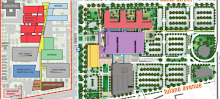
Here's my take on the other prong of the meeting - the presentation of the "very grand vision" for the UMC design (which the architect presenter said was final, when questioned, per the instruction of Mr. Jerry Jones).

The architect from NBBJ started off by noting that he had never been to New Orleans prior to working on the project - which elicited a few wide-eyed looks from a handful of people near me.  He referred to the need to be "a good neighbor" to the "transitional neighborhood" in the LSU Footprint.  As he showed slides of the quintessential New Orleans things like historic building facades that supposedly inspired the UMC building design, someone near me uttered: "That's what you're tearing down."

Hear are some interesting points about the UMC design that I picked up on:

- There will be a raised connector across Tulane Avenue to LSU
- A very large portion of the total LSU site will remain underutilized for an unspecified period of time into the future.  There was heavy emphasis on a need for future expansion.
- There is "no timeline" for when the full expansion will materialize
- The VAMC (VA Footprint hospital) will be different - "any expansion for them will be vertical" (so the taller of the two hospital complexes will be the one farther from the CBD)
- Supposedly all of the buildings laid out for the VA Hospital will "manifest in the first phase" when built, but I'm not certain that that's true - I will check.
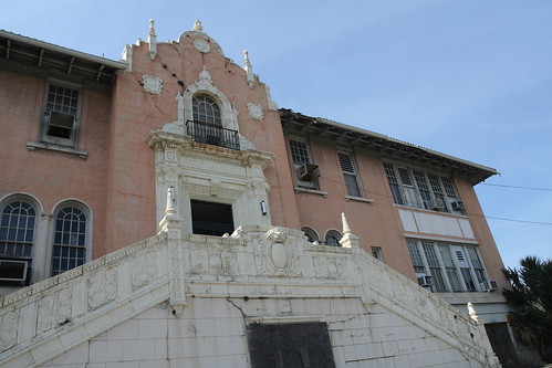
- The historic McDonough No. 11 School from 1879 seems to fall within an expansion zone only - not in a first-phase building zone (so it should be saved in the meantime) ADDED: I'm still trying to get a copy of the powerpoint; even if the school is not exclusively in an expansion zone, it's very close to the edge and the hospital building should have been reconfigured to include the building.  ADDED: Now that I have a copy of the powerpoint, it appears that the school building site will in fact be covered in the first phase.  But the map, on closer inspection, reveals how little was done to mitigate damage to Deutsches Haus and McDonough No. 11 - the areas left as parking lots for possible future expansion are the areas with few historic properties closest to S. Claiborne.
- A "Retail Corridor" is shown on Tulane Avenue, with retail spaces on the first level of at least one of the two parking garages that will front that thoroughfare (300 foot face, 30 feet deep).  One of the possible tenants mentioned was a uniform shop - which is somewhat ironic given that there's already a uniform shop facing Tulane Avenue in that location at present (Ellgee's)
- The complex will feature a "Cleveland Promenade" along what is now Cleveland Avenue - it will be a public concourse, but the images in the slideshow made it appear as if it was inside the building
- The building will feature images "pulled out" from old Charity - I think that's figuratively speaking.
- When questioned by a Board member on whether the architecture firm cross-checked the design with the business plan.  The architect presenter equivocated until Mr. Jerry Jones said: "So the answer is yes."
- Orleans House, the mansion at 1800 Canal Street, appears to exist on the map intact
- The Grand Palace Hotel building at Canal and S. Claiborne/I-10 will be demolished: "We're bringing it down," according to Jones.  It might eventually be the site of a medical office building "...at some point."  No word on whether the state will retain the existing multi-level parking structure attached to the building
- Pershing Place (also known as Billy Goat Park), which features a statue dedicated to World War I veterans, does not appear to be retained in its current form, nor did the statue seem to appear in renderings showing the idyllic corner of S. Galvez and Tulane.  It's in what's labeled as a plaza, so it should be retained.
- Overall, the site map for the design still seems incredibly wasteful, and appears sited on an unnecessarily large footprint.

The architect emphasized that there is no revising the plan - "this is it."  He also urged the Board to get moving to avoid "competition for labor with VA," noted, somewhat ironically, that the "joint" hospital across S. Galvez would raise costs for proceeding as it procured construction labor.  So much for synergy.

In other news, Mr. Rod West resigned from the Board.  The next meeting of the UMC Board will be on January 19, 2011.

Thursday, December 9, 2010

Orleans House is now For Sale


Apparently the mansion at 1800 Canal is now up for sale - after a sheriff's sale for the property was stopped (although other properties did proceed to auction that day):

30 Pallets of Bricks


Brick Man and friends have been busy in the VA Hospital Footprint, as evidenced by the salvaged bricks lined up on S. Galvez earlier today.

A New Neighbor


This vehicle appeared recently on the site of an old corner store and residence building that had been renovated in early 2010 prior to its demolition.

In the background, Outer Banks persists, still open in the evenings.

"planning on a scale that resembles the worst of the urban renewal era."

New Urban News published a great piece today about the failings of the LSU/VA hospital site in Lower Mid-City.

The blog post/article quotes a number of the individuals most intimately familiar with the drawbacks of the project - and links to this blog.

While I think the house moving aspect of the project was ultimately a positive - even if the roofs did have to come off because of serious time constraints - the piece nevertheless gives a better understanding of the laundry list of concerns the continue to encircle the site.

Remnants

Wednesday, December 8, 2010

Demolition Steam Rolls On in LSU Footprint


Demolition of movable historic homes continued today in the LSU Footprint.


The first three houses shown here - after salvage was well underway - are completely gone now, along with a fourth building just out of the shot at left.  Another streetscape lost.


LSU, the State of Louisiana, and the University Medical Center Board - which includes representatives from a number of institutions, such as Tulane - still do not have adequate funds to finance the construction of the proposed hospital.

Few Streets Remain in VA Hospital Footprint


Today, I found a patch of Cleveland Avenue torn up just below S. Tonti Street.  Cleveland is also no longer a street just outside the Footprint from S. Rocheblave to S. Dorgenois - it's torn up several feet below grade (affecting people who don't even live in the Footprint in a major way).

A patch of Palmyra Street, too, was gone - the block above Outer Banks. 


Thus, two of the remaining thoroughfares through the site were drastically limited today.  Technically, there is no longer a legal way to get through the streets of the VA Footprint - if you still count one-way requirements.  To drive through the Footprint, for those of you familiar with the site, one would have to drive the wrong way up Palmyra Street from S. Galvez, turn on S. Tonti and head up the one-way on Cleveland to S. Rocheblave, which is not really a street at this point, and turn left to head across the dirt over to Banks.

That's just fair warning to anyone attempting to drive or walk through. 

Still, it does not seem that law enforcement has been overly stringently in requiring adherence to the old one-way requirements, which is fortunate for the residents and the business that remain.  I would be cautious nonetheless.

UPDATE: Staff at Outer Banks bar say the police have okayed using what's left of Palmyra Street as a two-way street.